The East Columbia Neighborhood Association invites neighbors to a special meeting on Wednesday, August 12, promptly at 7:00 PM.
Location
Columbia Community Bible Church 420 NE Marine Drive Portland, OR 97211
Discussion topics
Transition Projects: Kelsey Stark, Program Manager, will introduce the organization’s program serving people experiencing homelessness at the former Motel 6 site.
City zoning proposal: Alice Walker will share the latest updates and discuss potential effects on local property values.
Trucking noise near Gertz Road: Alice Walker will provide an update on this ongoing neighborhood concern.
2026 ECNA events and volunteer opportunities: We are seeking volunteer nominees for Activities Committee Coordinator, Notifications Committee Coordinator, and Block Captains for Meadow Drive, South Shore Road, Lija Loop, and Mariners Loop.
We’ll also share updates on Movie Night, the Cookie Bakeoff, Halloween on Meadow Drive, and the Chili Cookoff.
We hope you can join the conversation and help shape the year ahead for our neighborhood.
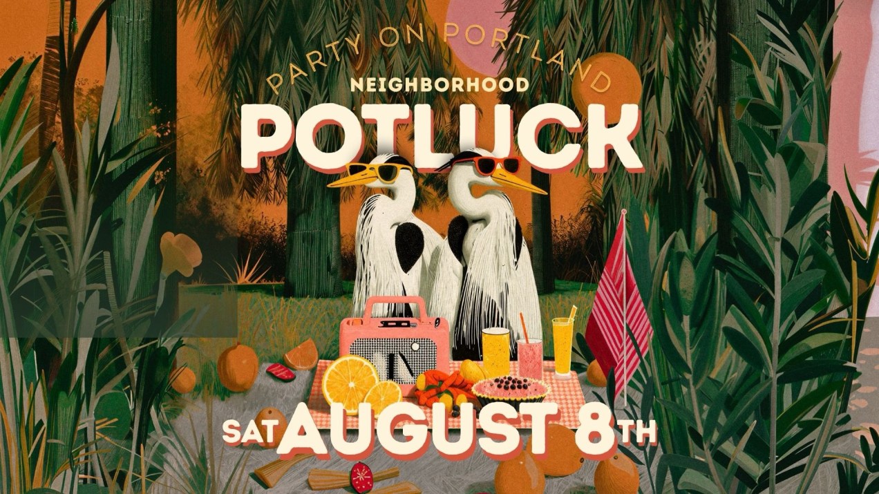
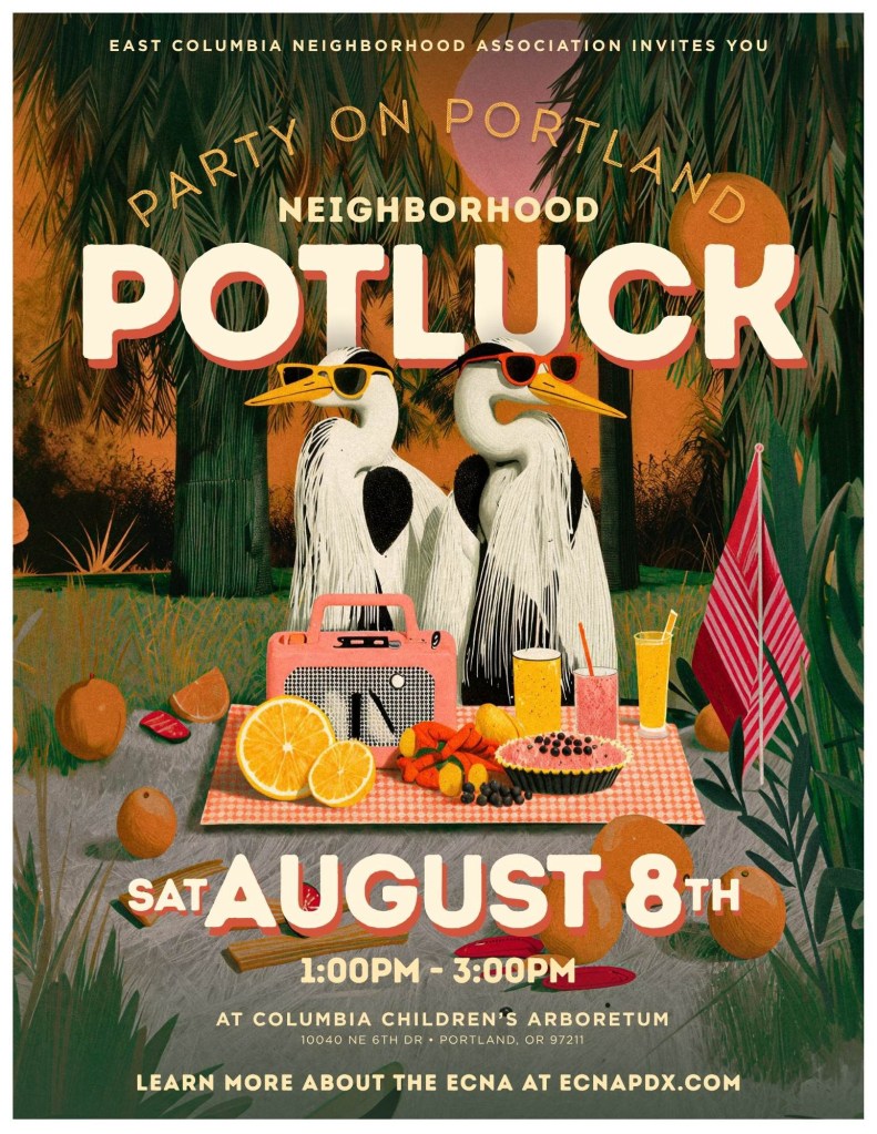
Join the East Columbia Neighborhood Association for our annual neighborhood potluck on Saturday, August 8, from 1:00–3:00 PM at the Columbia Children’s Arboretum.
Spend the afternoon meeting neighbors, connecting with ECNA board members, and enjoying food, conversation, and family-friendly lawn games, including cornhole, Giant Connect Four, badminton, and sidewalk chalk.
What to bring
Please bring a picnic side dish to share. Secret family recipes are especially welcome!
ECNA will provide:
BBQ ribs
Rotisserie chicken
Blueberry pie
Assorted drinks
Location and parking
Columbia Children’s Arboretum 10040 NE 6th Drive Portland, OR 97211
Follow the event signs from NE 13th Avenue to parking on Meadow Lane near the park’s east entrance.
No RSVP is needed. Just show up! Bring your family, bring a neighbor, and come enjoy an afternoon together in one of East Columbia’s most beautiful community spaces.
Columbia Community Bible Church invites neighbors to a Community Yard Sale on Saturday, July 25, from 9:00 a.m. to 2:00 p.m. at 420 NE Marine Dr.
Community and church members will be selling household goods and other choice finds. Come browse for a cherished item or two—some parking is available on site, with additional parking on surrounding streets.
Want to Sell?
Bring a table or blanket and set up on the back lawn at no charge. Please arrive around 8:00 a.m. to choose your space and unload. About 18–20 seller spaces are available, so please register soon. Sellers must remain on site with their items; no drop-offs are accepted for others to sell.
A light lunch of a store-bought sandwich, chips, and water will be provided for sellers.
Reserve Your Space
To reserve a selling space or ask a question, contact Pastor Steven Boyle at 503-240-0923 (calls only; no texts) or s.sboyle91@gmail.com.
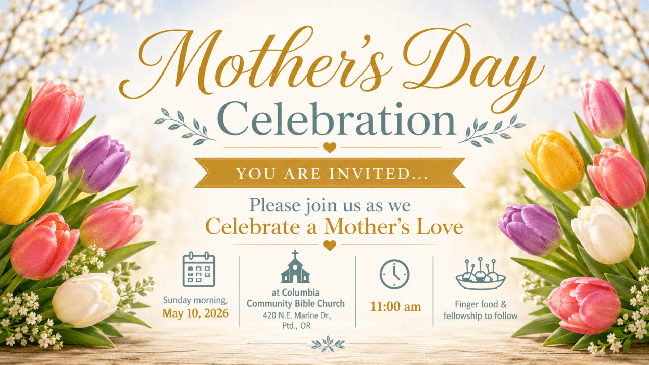
TL;DR: Columbia Community Bible Church is inviting neighbors to a special Mother’s Day Celebration on Sunday, May 10, 2026, at 11:00 AM. The event will include a morning gathering celebrating the love and care of mothers, followed by finger foods and fellowship. All are welcome.
Columbia Community Bible Church is inviting neighbors to a special Mother’s Day Celebration this Sunday morning. The gathering offers an opportunity for community members to come together, celebrate the important role mothers and caregivers play in our lives, and spend time connecting with neighbors in East Columbia.
Event Details
Mother’s Day Celebration Date: Sunday, May 10, 2026 Time: 11:00 AM Location: Columbia Community Bible Church 420 NE Marine Drive, Portland, OR 97211
Finger foods and fellowship will follow the morning celebration.
Community Invitation
Whether you regularly attend church services or are simply looking for a welcoming community gathering on Mother’s Day, all neighbors are welcome to attend.
ECNA is sharing this event as a community notice to help neighbors stay informed about local gatherings and opportunities to connect.
We appreciate local organizations and gathering spaces that help bring neighbors together and create opportunities for connection across our community.
For more information, contact Columbia Community Bible Church directly.
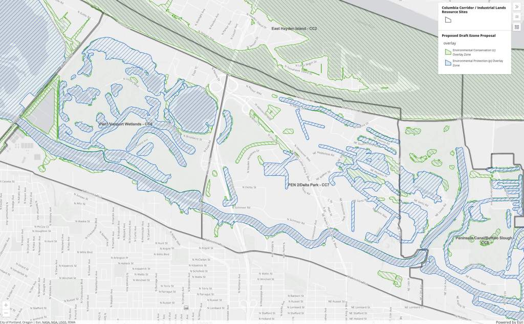
TL;DR: All three District 2 City Councilors toured East Columbia on April 10 to see how proposed wetland buffer zone expansions could restrict what you can build, farm, or do on your property — and significantly reduce land values for many neighbors. Join us at our Open House on May 6, 6–8 PM at Columbia Bible Church to learn more and make your voice heard.
Hi neighbors! On April 10, ECNA Chairman Patrick Henry and neighbor Gary Kunz led all three District 2 City Councilors — Sameer Kanal, Dan Ryan, and Elana Pirtle-Guiney — on a driving tour of East Columbia. The goal: to show them, street by street, how proposed Environmental Zone (E-zone) overlay expansions could affect residential, farming, and commercial properties throughout our neighborhood.
What’s Happening
The City of Portland is considering expanding protected buffer zones around wetlands connected to the Columbia and Willamette Rivers. Under the proposed zoning changes, properties near these waterways — including many in East Columbia — would be classified as “environmental zones,” restricting what owners may build, add, or do with their land.
One important distinction: most waterways in our area connect to the river through pump stations, not natural tributaries. Fish cannot pass through them. Despite this, the proposed overlays would treat these pump-connected ditches and engineered wetlands the same as natural river corridors — placing many private properties under environmental restrictions without a direct ecological connection to the river to justify it.
You can explore the CCIL project and see how the updated E-zone mapping may apply to your property using the City’s interactive map: portlandmaps.com/bps/ccil
What the Tour Covered
Neighbor Alice Christine Walker met each touring group along Gertz Road and walked the councilors into the brush to “ground-truth” the actual conditions on the ground. The tour included properties near the Oak Harbor Trucking business, a parcel straddling South Shore and Faloma Roads, a Marine Drive home, several Meadow Drive homes, and a Blue Heron home. In each case, the proposed buffer zones covered all or most of the privately owned parcel.
Walker also brought her expertise in farming and land preservation programs to the tour, explaining how the proposed changes affect not just homeowners, but also larger landowners with Oregon-protected farming rights. She highlighted a particularly striking example along NE Gertz and NE Levee: a wetland created by Oak Harbor Trucking as a condition of paving over their truck yards. Under the proposed overlays, that mitigation-created wetland could now be used to reclassify adjacent traditional farmland as an environmental zone — denying those landowners their ability to raise animals and grow food crops.
Why This Matters for Your Property
For many East Columbia property owners, the proposed buffer zones could mean:
Restrictions on adding ADUs, garages, or other structures on your property
Loss of Oregon-protected Right to Farm protections for larger and agricultural properties
Reclassification of pastureland as “wetland,” changing what you’re legally allowed to do with your land
A meaningful reduction in property value
The councilors saw these realities firsthand. Now we want to make sure the broader community understands what’s at stake — and has a chance to weigh in.
Open House: Come Learn More and Have Your Say
Date: Tuesday, May 6 Time: 6:00 – 8:00 PM Location: Columbia Bible Church, 420 NE Marine Drive, Portland, OR
All neighbors are welcome — whether your property is directly affected or you simply want to stay informed. Come with questions, bring a neighbor, and help us shape the direction of this conversation with the City.
Together, we stay informed. Together, we advocate for East Columbia.